Saturday, September 29, 2012

AT in NH: Valley View Campsite to Pinkham Notch - Home Stretch


Appalachian Trail, White Mountains, NH – 8/20/12 – Valley View Campsite to Pinkham Notch Visitor Center  – 8.3 miles

My neck had been a little sore ever since my slip-and-fall on Day 1, but this morning it felt especially stiff.  Today, however, it would take a lot to spoil my good mod because we were hiking to our finish line at Pinkham Notch Visitor Center where Judy’s sister Deni was picking us up.  As every hiker/backpacker knows, the only thing better than the beginning of a hike is the end of a hike.  

We woke up to sunshine very early, 5:30 a.m. and began the business of packing up.  Our tents and ground covers were soaked with dew but since we were ending today we stuffed them into their sacks and would deal with drying them out later.  By 6:30 a.m. we left Valley View and hauled our backpack-laden butts back up that ridiculously steep trail to Madison Hut.  There we filled water containers, used the facilities (flushing toilets!) and said hello to our LOTC friends.  Judy chatted it up with the young thru-hikers who were waiting outside to complete their work-for-stay breakfast cleanup.  We all put our feet in for a good luck photo.


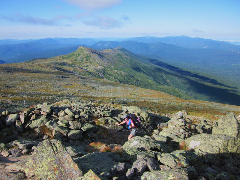
The AT switched to follow the Osgood Trail and at 7:30 a.m. we started our ascent of Mount Madison, one of the Presidential peaks that the AT actually summits and our last steep test of mettle for this New Hampshire adventure.  I think it was the toughest test of all.  Imagine that God took an enormous rock, nearly a mile high, and hit it with a mighty sledgehammer.  Imagine the rock cracking and breaking up into a heap of rubble, no soil to hold it together, just loose rocks ranging from the size of a basketball to the size of a Volkswagen.  Then God says, “Okay, get to the top of that the best way you can.”  Welcome to Mount Madison. 


The glorious morning sun emerged from directly behind Mount Madison, beaming a piercing spotlight in our eyes as we climbed.  There is no trail whatsoever, just moving from one 6-foot rock cairn to the next.  I couldn’t even tell which side of the cairns was better, passing some on the left and some on the right.  Sometimes I had to back up and go around the opposite side, constantly looking up, squinting, shielding my eyes from the sun to see if I was still on course.  I only took a couple of photos of this segment.  Judy put away one of her hiking poles and shortened the other to use her hands for balance.  I stuck with my poles but I’m not sure it made anything better. 


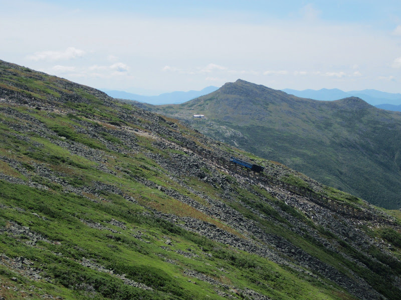
Looking down at Madison Hut with Mount Adams in the background – thank goodness we didn’t have to climb that too – some hikers said it was even worse than Madison

The half-mile to the summit took us 1.5 hours, elevation gain a bit under 600 feet, every step a logistical challenge.  I think Judy rewarded herself with a few Snickers, always a good incentive.  There were several groups at the summit, including some amusing New Zealanders who commented on the spectacularly clear blue sky:  “This is New Zealand on a bad day.” 

The feeling of elation that blossoms in the chest when a tough challenge is met – the summit of Mount Madison!  Look closely to see the tiny towers on Mount Washington under my right elbow

Some of our friends from LOTC – never pass up the chance to get in the middle of a photo with handsome men

No more tough climbs, home free now, right?  Not exactly.  Now we faced the part I had both longed for and dreaded, a 3,000-foot descent in 3 miles, sort of the bookend to the ascent of Mount Webster.  Our lungs would be spared but our knees would suffer, plus going down a steep pile of loose rocks is at least as slow as going up.  The character of the trail now consisted of a brief plateau section followed by a short, steep descent, repeating several times. 

The guys quickly pulled ahead of us and disappeared. 

Me:  Look at what we just went over!  Judy:  I don’t want to look.  Mount Madison in the foreground, Mount Adams in the background

When the trail descended below the tree line the character changed again.  Believe it or not, the steepness increased – no more plateaus – but the large rocks were embedded in soil and the trees hugged us close.  I was bummed to lose the big views but Judy was ecstatic to be back in the more familiar terrain of the AT.  The uneven big steps led unrelentingly down the mountain.  My right knee began to ache so I began to compensate by always stepping down with my right foot (bending my left knee instead), knowing that I would wear out my left knee too. 


Altogether the 3 miles from Madison Hut to the Osgood Camp intersection took us 4 hours, excruciatingly but necessarily slow, and my patience wore thin.  I was hungry but too stubborn to stop to eat before the intersection. 

An older fellow, a section hiker who had been leapfrogging with us for a couple of days, descended down the green tunnel with us and also stopped at the Osgood Camp intersection.  As he prepared to move on, I pointed to the trail signs and said, “Look at the signage there, I think the AT goes that way.”  Well, he took off in the direction I pointed without consulting the sign.  Ten minutes later when Judy and I looked at it, we saw that the trail turned and that he had gone in the wrong direction.  Too late to catch him.  We figured that he would intersect with the road in a few miles and realize the mistake.  I felt only a little bit bad because he should have checked out the trail sign plus his map and confirmed the route.  Who was it that said “Trust but verify”?

In fact, the AT makes several turns in the last miles going to Pinkham Notch so every intersection required consultation with the map.  Past the Osgood intersection the trail leveled out and we celebrated the creek crossings and soft dirt floor.  Judy was quite happy, back in the forest environment that she loves.  She stretched her legs and moved ahead.  By now my right knee was quite stiff and my thighs were sore, so I kept an easy, relaxed pace. 

West Branch of the Peabody River

Bridge over the West Branch of the Peabody River

Interesting fungi and ferns

A familiar sight:  trillium

Judy rock hopping a stream

The trail crossed the Mount Washington Auto Road and we took a rest break.  Occasionally cars passed by and slowed down to look at us.  Why?  Do we look like an exhibit or creatures in their natural habitat?  One couple stopped and asked lots of questions:  Had we hiked to Mount Washington?  Was it scary?  They had driven part way up the road but turned around because it looked too dangerous. 


Our last trail section was Old Jackson Road, two miles of cruising at 2 miles per hour.  We passed one older couple, moving slower than us but looking very fit with sturdy legs, out for a short hike as they were passing through the area.  A good example for us.
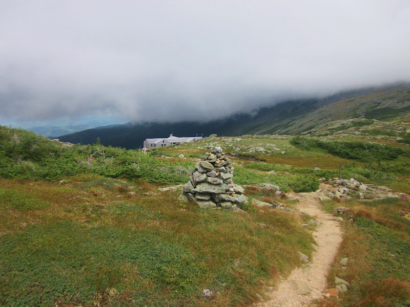
And there it was:  Pinkham Notch Visitor Center.  It was 3:30 p.m., 9 hours since we left our campsite this morning.   And of course they closed the snack bar at 3:00 p.m.  Inside the VC I saw the section hiker who had taken the wrong direction, and when I said hello and tried to inquire about his hike, he looked at me and walked off.  I guess he held me responsible for his detour. 


We took our boots off and sat on the bench at the VC until Judy’s sister arrived at 5:15 p.m.  I collapsed into the back seat of her car in a semi-coma for the 2+-hour drive to her home near Manchester.  Once there, a good shower, a glass of wine and a great meal prepared by Deni’s husband, Fred, and I was ready for one thing:  bed. 

Why does it feel so good to stop hiking? Why do we immediately start planning the next trip?  Always chasing that feeling of challenge and triumph, and ultimately finding connection, humility and gratitude.

Here I am, safely returned over those peaks from a journey far more beautiful and strange than anything I had hoped for or imagined - how is it that this safe return brings such regret?
~Peter Matthiessen


Thursday, September 27, 2012

AT in NH: Mount Washington And Beyond - Lake of the Clouds Hut to Valley View Campsite


Appalachian Trail, White Mountains, NH – 8/19/12 – Lake of the Clouds Hut to Valley View Campsite – 7.6 miles

Faint light through our dungeon window awakened us early.  We were out of our bunks by 6:30 a.m., washed up, prepared and ate our breakfast in the LOTC dining room.  We had a minimum of 7 miles today and expected it to be slow going, so no time to waste. 

Stepping out into the chill, we turned our faces towards the trail and stopped to marvel:  blue sky, a lacy wisp of cloud over Mount Washington....

...and a cottony blanket of clouds down over the valley.  Can you see where the name “Lake of the Clouds” comes from?

Another interpretation of "Lake of the Clouds"

The first big pile of rocks to climb today was Mount Washington, carefully choosing our footing across a boulder field with only rock cairns as guides.  I say “first” because pretty much all day was the same, above tree line navigating one boulder field after another.  The good news was the clouds dispersed for a wide-open blue sky and we could see for miles and miles in every direction…all day long.  This was quite a gift because Mount Washington is famous for having the “worst weather on earth”.  Today there wasn’t even a noticeable breeze.  For me the expansive views definitely made the rocky terrain worthwhile. 

Saying goodbye to Mount Monroe and Lake of the Clouds Hut

I took a dozen photos looking backwards as we climbed – this is Judy and Mount Monroe and a tiny LOTC

Most of the rock cairns featured a chunk of quartz larger than my head

Ugly but necessary equipment towers on Mount Washington – can you believe it was hard to get a cell phone signal?

We were ahead of most folks getting to the summit, i.e. the cog train and driving tourists had not yet arrived.  Sadly, the snack bar was also not yet cooking.  There’s a hospitable hiker lounge on the lower floor with tables and chairs, outlets for recharging things, and most importantly, bathrooms and showers.  We hung around for an hour or so waiting on sandwiches from the snack bar, threw away trash and did one last edit of pack weight, tossing out a little bit of food.  We briefly considered riding the cog railway down and back up the mountain, but the fee ($62) and the time involved made us say no.

Here the AT changes from the Crawford Path to the Gulfside Trail, more presidential summits ahead.  Overheard remark from a female hiker ahead of us:  “Next is Mount Clay?  That one must be named for those people who lost a presidential election.  Come on, let’s go climb Mount Romney!”

Standing on the cog railway tracks

Click on this photo to enlarge it and see the cog train ascending Mount Washington, with Lake of the Clouds Hut (shining roof) and Mount Monroe in the center background

The women ahead of us (the Romney joke) mooned the train as it went past, a tradition amongst AT thru-hikers and apparently anybody who feels like it.  The conductor shook his fist at them and yelled, maybe threatening to arrest them later?  How would he identify them?  Well, it is a family train…We just smiled and waved politely as it passed us.

We’re going over all those mountains

Do you see a trail?  Neither do I.

Typical character of the trail today.  Most intersections were well signed, but the only indication of trails was rock cairns leading off in different directions. 

Mount Clay – once again the AT skirted around the contours while a side trail went to the summit. 


Judy was cool with summiting Mount Washington, but the relentless boulder fields did not improve her opinion of New Hampshire as she continued to be extremely cautious and uncomfortable.  Fortunately she is very strong physically so she just sucked it up like a pro and kept going.  I felt more confident with the rock surfing than on the first day and the climbs were not as extreme, but I still didn’t want to foolishly twist an ankle.  We moved slowly enough not to get hopelessly exhausted, but as the day wore on the rocks got more challenging and we grew weary.  One mile per hour was our top speed.

During one rest stop I stepped on one of my new hiking poles and bent it, had to fiddle with it and readjust to keep the proper length.  Once you’ve bent a pole you can’t really trust it.  (Once back home I returned it to REI, walked out five minutes later with a new set of poles.) 

Huge hunk of quartz on the trail

Mount Washington over Judy’s shoulder.  From there the AT follows the ridge line in a huge semi-circle to the right, so we could see Mount Washington all day and even the following day.

A little outcropping fun near Mount Jefferson

Interesting ridge lines

Hobbit-esque patch of stunted trees near Israel Ridge

A rare AT blaze – the yellow blaze represents Gulfside Trail

Near Thunderstorm Junction – here the AT skirts the contours of Mount Sam Adams.  Some clouds were beginning to form, the hour was getting later and we were ready to be done but still had a couple of miles to go.  A few thru-hikers passed us, mostly young guys moving at high speed, not what you want to see at the end of a tiring day.  Our goal was to score two guest bunks for the night at Madison Hut, our only hope since they don’t have emergency shelter like LOTC does.

Madison Hut at last – and Mount Madison, the rock pile behind it, which we will have to deal with in the morning

No room at the inn for us, but we got to say hello to some fellow travelers we’d met at LOTC.  So what are our options?  A campsite about a half-mile down the Valley View Trail…down meaning straight down, steeply down, ridiculously steeply down.  By now my tank of optimism was running low, but Judy was perked up because we were again below tree line and the Valley View Trail was enclosed by thick woods which made her feel safer.   

After a lifetime of descent we found the side trail to the campsites, small spaces strung out along the still-steep mountainside.  There was one fellow at a neighboring site who we chatted with briefly.  He was wearing jeans, didn’t have a tent, was trying to cook some foil-covered objects, said he was a grad student just out for some fun for the weekend.  As we went to set up our site Judy commented that she hoped we didn’t wake up dead.

A little hiker humor there, folks, everything was fine.  He was a nice young man.

Alpine glow sunset on the mountain with the privy in the foreground.  We go to the nicest places.

Our site was very quiet, peaceful and secluded.  Judy and I agreed that we were happy to skip the hut social scene.  It felt great to take a bird bath and change clothes completely from the skin out, a little cleaned up for our last night on the trail.  We cooked, ate, toasted Day 3 with a little brandy.  I fell asleep to the babbling sound of the nearby creek.

“Mountains should be climbed with as little effort as possible…The reality of your own nature should determine the speed.  If you become restless, speed up.  If you become winded, slow down.  You climb the mountain in an equilibrium between restlessness and exhaustion.  Then, when you’re no longer thinking ahead, each footstep isn’t just a means to an end but a unique event in itself.”  ~Robert M. Pirsig, “Zen and the Art of Motorcycle Maintenance”


Wednesday, September 26, 2012

AT in NH: Nauman Campsite to Lake of the Clouds Hut


Appalachian Trail, White Mountains, NH – 8/18/12 – Nauman Campsite to Lake of the Clouds Hut – 5 Miles (5 hours)

The slight drizzle during the night tapered off quickly and we woke to a foggy morning.  I rested hard but a little too warm, didn’t need the 15-degree sleeping bag zipped up.  Judy repacked her gear and improved her pack stability.  (She even poured out half of her brandy to reduce weight!)  We were on the trail by 7:40 a.m., carrying a little anxiety for what the day would hold.  The dilemma we faced was whether to stop at Lake of the Clouds Hut (5 miles) or continue up and over Mount Washington and on to the next legal camping spot (9.6 trail miles plus a 1-mile detour off the trail to the campsite = 10.6 miles).  Unless the hiking was significantly less complicated than yesterday, there’s no way we were going to make it 10+ miles.

We knew that the trail would continue to trend upwards, and immediately past Mizpah Spring Hut we met a half-mile steep climb, more rock walls and even a ladder.  Okay, say it with me again:  We can do this.

As we climbed higher, the trees became shorter and boards helped us stay on the trail in the fragile ecosystem. 

Rocks line the trail to guide hikers

We were now on the Crawford Path, the oldest continuously maintained hiking trail in the United States.

Say hello to Mount Pierce (aka Mount Clinton, but don’t ask me why).  

There were lots of people out this morning, most having spent the night at Mizpah Spring Hut and hiking on to Lake of the Clouds Hut.  Tall rock cairns now appeared regularly as we emerged above tree line, and you can see in the fog why they are so necessary.

One group that we leapfrogged for a while consisted of four teenage girls and five adults with daypacks.  The girls were playing some type of memory word game, very loud, not really paying attention to their surroundings.  At a sleepover this would have been normal, but not what I wanted to hear in this glorious outdoor setting.  They were faster than us, but stopped frequently.  We would let them pass, then catch up and pass them as they took many rest breaks.  We lost them once when they took the side trail over Mount Eisenhower (the AT skirts around this mountain), but darned if they didn’t catch us again.  Fortunately they planned to continue past Mount Washington today, so they finally hiked on into oblivion.

I don’t know the rhyme or reason for the AT route through this area called the Presidentials.  The trail goes over some peaks and skirts around others.  If you’re a thru-hiker the choice is obvious, but for peakbaggers it’s a dream:  forget the AT and hit all the summits. 

As the morning progressed the clouds played hide and seek.  This is one of my favorite photos of the entire trip:  Judy and Mount Eisenhower. 

Going around Mount Eisenhower.

People going up and down to the Eisenhower summit

Five minutes later, clouds rolling over Eisenhower

Looking back at Mount Eisenhower.  The wide open terrain reminded me of hiking in Switzerland and the views (when the clouds cooperated) seemed endless. 

We passed a father with his three young boys, ages 8, 6 and 4.  The two older ones wore their own daypacks and carried their own little hiking poles.  The 4-year-old scampered around like one of Heidi’s goats.  They were on a multi-day hut-to-hut trip.  I have never seen anything like that in North Carolina.  Everyone we met during our White Mountains adventure seemed well outfitted with proper footwear and gear, none of this stepping out of the car in flip-flops and walking 100 feet up the trail (granted, we were up at the summits that are a challenge to reach).  As for fitness, I felt like I was the “fat” person on the trails. 

The AT led us over Mount Franklin and then we caught our first glimpse of Mount Washington (home of communication towers).  At 6,288 feet, Mount Washington is the highest peak in the northeastern United States and, of course, the New Hampshire state high point. 

At last Lake of the Clouds Hut came into view, but look at the cloud cover. What was the weather going to do the rest of the day?  It was 12:30 p.m.

The five miles to LOTC was easier than yesterday, but still strenuous, some rock surfing and slow, tedious hiking.  It took us 5 hours to go 5 miles.  There was no guarantee that the next 5 miles to the next stop would be easier, plus we would have to hurry over Mount Washington without stopping to relax (and, yes, enjoy food at the snack bar).  Ultimately, although it seemed quite early, we decided to stay at Lake of the Clouds.  We resolved ourselves to enjoy the afternoon as a gift of time.

We threw ourselves on the mercy of Emma, the staff person in charge, and asked to stay in the “hiker dungeon.”  She said that was intended as emergency shelter for late arriving hikers and they didn’t usually start accepting people until after 3:00 p.m., but when I told her I’d sit and wait until 3:00 p.m. and ask her again, she relented and signed us in.  The cost is $10 per person and for another $10 you can buy dinner.  Since we had lugged our food this far, we opted to cook our own dinner. 

The hiker dungeon is downstairs underneath the dining room.  It looks like it used to be storage.

Home sweet home

Judy and I took seats on benches in the dining room and ate lunch with a view of Mount Washington out the window, in and out of clouds.  It looked so close (only 1.4 miles) yet so unattainable today. 

The dining room

After resting a bit and eating and inspecting the facilities (composting toilets and treated water), we decided to climb the mountain next door that the AT had skirted around, Mount Monroe, as a consolation (thus we bagged another 4,000-footer).  Again, loads of people plus some well-behaved dogs were going up and down this mountain. 

On the summit of Mount Monroe 

Looking down at Lake of the Clouds Hut - Mount Washington totally obscured by clouds


Judy seemed to be doing okay on today’s hike, not as treacherous as yesterday, and she wanted to do a little more hiking.  I was happy to just return to LOTC, so she descended down the far side of Mount Monroe and circled back on the AT.  A little down time was good for both of us and I was glad to see her enjoying herself.  (Side note:  when she got back to LOTC she reported that the descent was rocky and unstable and never to let her do that again – haha).  I noticed that in talking with people she complained about the difficulty of the rocks and that she no longer wanted to finish her goal of section hiking the entire AT because there was more of this terrain ahead and she felt it was too dangerous.  I empathized greatly with her because I hated crossing snow fields in the Grand Tetons and never got comfortable with it.  It is my fervent hope that with a little time for contemplation she will renew her goal.  And I remember that after summiting Mount Whitney I was sure I never wanted to do anything remotely as strenuous ever again – and yet here I was in the White Mountains, which felt a lot like Whitney but with oxygen.  In the meantime, during our NH adventure I tried to be vocal that although we ain't in Kansas anymore (i.e. different terrain than back home) I was having a different experience and felt okay with it. 

Back at the LOTC hut I sat outside on a bench and struck up conversations with fellow hut guests.  Most were surprised to hear about the hiker dungeon accommodations.  When Judy returned, we chatted with a man who, upon hearing we were from North Carolina, told us about a hiker friend of his in Tennessee that he had originally met at the New Hampshire huts.  He’s been to Tennessee to visit and has hiked a little bit in the Smokies.  Then he described to me a great guide book he picked up there, saying he would likely never get to do any hikes from the book but felt it was so well written that he bought it to read for fun.  Had I ever heard of an author named Danny Bernstein?  Small world again.

One gregarious fellow we chatted with several times went by the trail name of T-Bone.  He has hiked all around the White Mountains for many years.  We told him our trail names were Heartfire and Smoky Scout, and from then on he called us “Heart Throb” and “Smoky Princess.”  If you like socializing at the end of the day, try hiking in the White Mountains. 

Judy and I got out stoves and our backpacker meals and cooked near the benches at the front door.  My cuisine is made by Mountain House but Judy dehydrates her own meals. Then we enjoyed another brandy toast for Day 2.

Hut staff prepared a turkey dinner complete with homemade bread.  Yeah, my Mountain House pasta primavera tasted dee-lish. 

After eating, I sat inside and looked through the hut’s guest books (they have all of them dating back to when the huts first opened – you can go back and find what you wrote in 1974).  The staff made a big display of introducing themselves and explaining how the hut works, and it was apparent that these staff jobs are valued and much sought after.  It felt like being at summer camp.  Outside, Judy was talking with some young thru-hikers who were doing work-for-stay (in exchange for cleaning up after dinner and breakfast they would be allowed to sleep in the dining room for free).  One of the thru-hikers, a young law student named Blind Faith, would be sleeping in the dungeon with us.  Judy came in to tell me that the sunset was looking spectacular and I joined her outside.

The other hut guests drifted outside to see the sunset, too, and it was breathtaking. 

Smoky Scout at sunset

Judy’s sunset photo

Then the guests went back inside to play cards and board games in the dining room, and after hanging around a short time we headed to our basement bunker directly beneath the action.  Loud voices and thumping around couldn’t compete with my state of exhaustion plus ear plugs and I fell asleep soon.  Sometime during the night Blind Faith crept quietly into his bunk above me.  And at 1:00 a.m. I went outside for a bathroom break and was nearly knocked down by the stars.  I felt like I could reach out and grab the handle of the Big Dipper. 

When I admire the wonders of a sunset or the beauty of the moon, my soul expands in the worship of the creator.  ~Mahatma Ghandi