Thursday, June 28, 2012

Training for Mt Kili (No, Not Me)


Mt Mitchell Trail – 5/5/12 – 6.5 Miles

My neighbor Mark mentioned back last winter that he and his son Jason were joining a group to summit Mount Kilimanjaro in June 2012.  He knows I’m a hiker (he isn’t) and asked for a little advice.  What could I say?  “Go hiking – oh, and carry a heavy pack.”  Now, Mark has a full-time job and a wife and a dog and other interests and I know he’s not going to drive to western North Carolina every weekend to climb a mountain.  He’s a very fit and strong guy (cyclist) and I’m a little skeptical that he will train for an experience that is going to cost a lot of money and that he may not complete.  But I learned that Mark is also very disciplined and serious about commitments, and he did train nearly every weekend at our closest little bump, Crowder's Mountain. 

So what could I do to help?  I took him to climb Mount Mitchell, the tallest mountain in the eastern United States at 6,684 feet.  Yeah, it’s not Kilimanjaro at 19,340 feet, but it’s as good as we got ‘round here. 

The Mount Mitchell Trail from Black Mountain Campground to the summit of Mt Mitchell is 6.5 miles.  I wanted to hike up and then down, but due to the long drive to and fro and other time constraints we had to make it a one-way hike.  My husband Jim stepped in to help out, agreeing to drop us off at the trailhead, then drive to the parking lot at the top and go for a bike ride on the Blue Ridge Parkway while we hiked.  (It is not hard to get Jim to go for a bike ride on the Parkway.)

Rain in the forecast turned into rain in real life.  As we turned onto the Blue Ridge Parkway it was coming down rather seriously and Jim was thinking he’d be reading a book in the car while he waited for Mark and me to hike up.  At the trailhead we suited up for a wet day. 


But…the woods were dripping but not pouring, and within 20 minutes the rain gear came off and we hiked the rest of the day with intermittent clouds but no rain.  Ain’t life grand?

Mark’s pack cover – it worked – it didn’t get wet!

The Mount Mitchell Trail runs concurrently with the Mountains-To-Sea Trail as it climbs about 3,500 feet to the summit, some parts steeper than others but every step moving upward.  Some fun stuff:

A neon orange salamander

Mark’s lunch bag

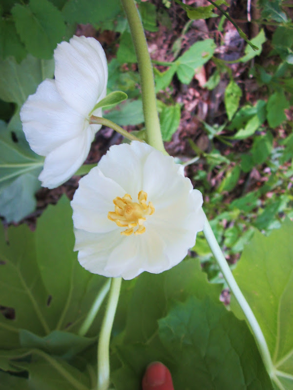
A great year for rhododendrons

Hhmmm… which way?

At about 1.5 miles the trail splits, but either direction is okay – it comes back together after just a quarter mile.  We took the left track, also known as the Higgins Bald Trail, only to find that Higgins Bald… is not.  The forest is taking it back.

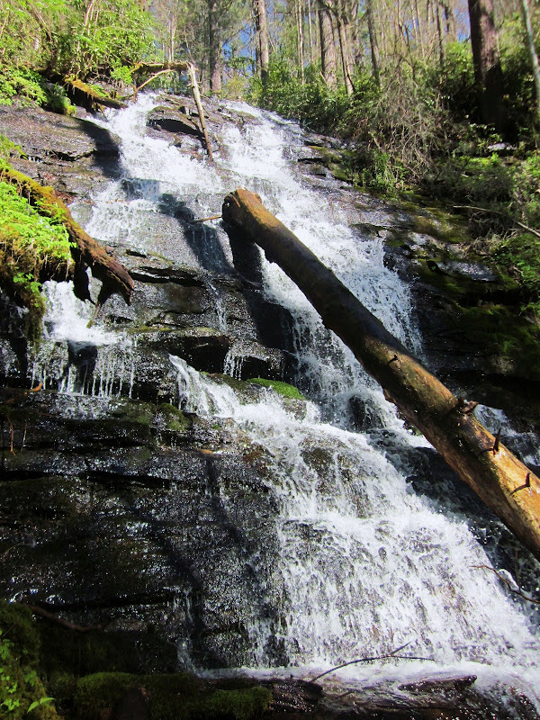
A pretty stream crossing - as it goes over the edge to make a waterfall we can only hear. 

A big bad blow-down

Early in the hike we met a couple that hikes around Mount Mitchell regularly and the man was carrying a small chainsaw.  The week before they noted some storm damage and came back to take care of it, but someone had beat them to it.  Nice to have such dedicated local trail maintainers.

The trail switchbacks across an open area where power lines ascend the mountain.  While power lines are not pretty, it’s easy to look “through” them for the beautiful views.

In the last couple of miles the character of the trail changed from hardwoods to Fraser fir and hemlock, dense overhead, less sunlight, a Hansel-and-Gretel feeling.  We passed through an area that had experienced some of nature’s pruning during a fierce storm.

A small stream bubbling up over some interesting rock formations – looks like a quarry where the rock has been chipped out.

And we’re at the summit – Mount Mitchell!

Looking north to the SB6K and other peaks I have yet to conquer:  Mount Craig, Big Tom, Balsam Cone, Cattail Peak, Potato Hill

Looking east to Hawksbill and Table Rock at Linville Gorge (the "cat's ears" formation on the farthest ridge line)

Mark had no problems on this hike other than having to slow down for me.  Jim did get in a good bike ride, still a little wet and chilly, but a good day nonetheless, made better by introducing Mark to the Jack Frost Dairy Bar in Marion.  If you have never had ice cream at Jack Frost, get in the car right now and go there.

PS – Mark and his son Jason successfully summited Mt Kilimanjaro on June 24. 

The difference between try and triumph is a little umph.  ~Author Unknown


Sunday, June 24, 2012

Discovering Uwharrie National Forest


Uwharrie Trail - Uwharrie National Forest – 4/21/12 – 6.5 Miles

At the invitation of member Karl Munn, I joined an outing of the Uwharrie Trail Club for a spring Saturday hike in Uwharrie National Forest, over 52,000 acres of protected land about an hour’s drive east of Charlotte, NC – yes, east.  On several occasions I have visited Morrow Mountain State Park, which butts up to the western edge of Uwharrie, but I have never ventured farther into the country’s oldest mountain range.  You read that right:  oldest.  Once similar to the Rockies, erosion had its way and now the Uwharries top out at about 1,000 feet.

What was I waiting for?  I am embarrassed to say that Uwharrie, although old and important and all that, never seemed adventurous as I always looked west for higher elevation.  After a fine day with some fun folks, I have been educated. 

There are around 65 miles of hiking-only trail within the forest, plus sections that are multi-use (horse, bike, even ORV).  The major hiking trail running north to south is the Uwharrie Trail. (I’ve read that we can thank Joe Moffit, who grew up roaming the Uwharries during the Great Depression, for making the trail a reality in the 1970’s when he served as scoutmaster for a troop of Boy Scouts earning their Eagle rank.)  There are three major trailheads and a couple of other minor roads that cross the trail.  We hiked a chunk in the middle, from the Horse Mountain Trailhead on Tower Road (SR 1134) southbound to the NC Hwy 109 Trailhead. 

The crew:  Karl, Annette, Robert and Don, plus me

Is that gal wearing a skirt, you ask?  Why, yes.  This was the first time I’d met Annette and she certainly made an impression on me.  Annette is a gregarious local, happy to share her ideas and love of the Uwharries and some interesting stories about the area and its residents.  That smile did not fade all day long. 

There was more up-and-down than I expected on this trail and a couple of times we had to stop talking to get up one of the rolling hills.  So much for the flat Piedmont!   Annette was scouting for out-of-the way camping spots for a solo overnight trip she was contemplating.  She sometimes hikes alone, mostly out of necessity, but she said she finds it peaceful and contemplative, much the same as I do.  Actually, when I first asked her how she felt about hiking alone she promptly answered, “I am never alone because the Lord is with me.”  Did I mention that Annette is a pastor? 

Don also was born, raised and still lives in the area.  He and Annette shared a couple of stories about the by-gone days of moonshining and we saw some rusty evidence of that pastime.  Our favorite story that had us slapping our legs with laughter was about a community called Black Ankle.  Such an odd name!  Well, they say that you could tell kids from that community by their black ankles, from running around bare-legged near the fires beneath the stills. 

A muddy crossing

Mountain laurel were bursting into bloom overhead

Uwharrie is a popular destination for Boy Scout troops from the eastern part of North Carolina.  We passed many of them along the trails.  For some reason, the adults were always bringing up the rear…

Doesn’t this look like the result of some scoutmaster saying, “All right, boys, go build something”?  And how about that fire ring made with quartz stones?

Nice bridge over a large stream

There were several tent cities set up along that stream – do not go here for solitude

As we got closer to our exit, more people streamed in loaded for an overnight stay.  One fellow carried a Barbie pink cooler and a “cube” container full of water, must have been a couple of gallons. Sorry, no photos, just trust me.

A day well spent exploring a new-to-me area practically in my back yard.  I look forward to hiking the other sections of the Uwharrie Trail and some of its connecting trails too.

Of course there is much more to Uwharrie National Forest than the tiny slice I enjoyed, including boating and water activities on Badin Lake and many campgrounds.  Check out the resources here and here.

To me a lush carpet of pine needles or spongy grass is more welcome than the most luxurious Persian rug.  ~Helen Keller

Monday, June 18, 2012

Judy and White Oak Sinks


Smokies Hike With Judy – 4/13/12 – Turkeypen Ridge Trail/White Oak Sinks/Schoolhouse Gap Trail – 7.5 Miles

My friend Judy is narrowing down to her goal of finishing the Smokies 900 – only 20-something miles to go, but they are in bits and pieces that require extra miles to reach.  It’s been 18 months since we’ve hiked together and we had lots to catch up on:  children, her Lightheart Gear business, and other hiking adventures, including her hiking on the Wonderland Trail at Mount Ranier and my Mount Whitney summit.

Our goal today was to hike 3.6-mile Turkeypen Ridge Trail, which begins at Laurel Creek Road on the Tennessee side of the GSMNP (near Cades Cove).  Ordinarily this is a pleasant but ordinary little jaunt, not too much elevation gain or loss, and it can be combined with a couple of other trails criss-crossing Laurel Creek Road to make a decent dayhike loop.  But...today the wildflower show was in full swing and we were thrilled to get an eyeful of nature’s best offerings. 

Crested dwarf iris - so delicate and so detailed

I had seen crested dwarf iris on my solo backpack trip on the NC side of the park, but not in such profusion

Flame azaleas at eye level.  Unlike the shrubs in the typical Southern yard, wild azaleas grow like wispy trees and their colors seem to float

Judy has always been good at seeing tiny details at her feet and she spotted this lone yellow ladyslipper on the down slope

Sweet shrub

Can’t get enough photos of mountain laurel

Before we knew it we were at the end of Turkeypen Ridge Trail where it T’s into Schoolhouse Gap Trail.  And like the Holy Grail with a spotlight, there was a clump of yellow ladyslippers about 15 feet off the trail, with several worn paths encircling it where wildflower pilgrims have walked and knelt to photograph this rare orchid.  So glad to see it appreciated and not disturbed.

While we were having a lunch break by the ladyslippers, a large school group from Chattanooga strolled up, carrying notebooks/journals and cameras.  Their instructor seemed very laid back, said the process of their exploration was less important than the destination of their walk.  Their assignment was to record anything they saw of interest.

Foam flower

Rather than rack up more Smokies 900 miles, Judy and I decided to explore the area called White Oak Sinks, not an official trail or area in the Park but well known to wildflower enthusiasts for its riotous display of spring flowers.  Even the school group was headed there.  The unofficial and unmaintained (but really good) trail into White Oak Sinks is off of Schoolhouse Gap Road.   And what is there?

Dozens (hundreds?) of pink ladyslippers spread on a hillside

Large-flowered trillium

Mayapple foliage

And mayapple blooms

Yellow trillium

We walked deeper into the Sinks, at first discerning the main trail from numerous side trails and then finally giving in to explore several of the intertwining paths.  Judy and I had both been here before and had pretty good memory maps.  Purple phlox filled the open areas and gave off a distinct perfume. 

Waterfall in White Oak Sinks – some people were descending  down into the grotto but we stayed at the top.

Blowhole Cave in White Oak Sinks, no people allowed, just bats.  (Bats in the Smokies are suffering from white nose syndrome.)

Following a side trail as it climbed up a small ridge overlooking one of the meadows, Judy showed me a single grave of Abraham Law (1790-1864).  I have seen some information online that he and his wife had nine children and that the correct death date is 1844.  I wonder why he is buried up on that hill all alone? 


That is one big grapevine

After roaming around the Sinks trails for a bit, we left the Chattanooga crowd behind and located another unofficial trail that runs about a mile up a creek bed to the park boundary at the end of Schoolhouse Gap Trail.  Jim and I first hiked this trail back in 2008, when a homeowner on the boundary pointed it out to us.  We didn’t know what we were getting into at the time, but today Judy and I easily walked to the end.  There a good old hound dog good-naturedly guarded his homestead, but was not above begging for food as we took a snack break.

We walked back to our cars via Schoolhouse Gap Trail, a wide gravel road bed, a little boring unless you meet some horses, but it gets you from A to B.  And you better believe I marked it on my second Smokies 900 map.

(Another great blog post about White Oak Sinks is here.) 


Wednesday, June 13, 2012

Back To Where I Started - Solo Backpack


Solo Backpack in the Smokies – Day 2 - 4-12-12 – Indian Creek Motor Trail/Thomas Divide Trail/Deeplow Gap Trail/Cooper Creek Trail/Deeplow Gap Trail/Mingus Creek Trail – 12 Miles

I woke up at 7:15 a.m. after a 10.5-hour “nap”.  It was an eerily quiet night, no interesting animal sounds out beyond the safe walls of my silnylon tent.  I was a little disappointed.  I at least expected to hear an owl out there somewhere.  No crickets, no frogs…too cold, I suppose. 

And it was cold, about 30 degrees.  I slept in a few layers but not everything that I had brought.  The condensation on the inside of my tent froze soon after I exited and I got frozen fingers while packing up.  (I’m not too picky about packing a wet tent if I’m not sleeping in it again; I just stuff it into a plastic garbage bag and strap it onto my backpack.  When I get home the tent gets spread out in the garage for several days to dry thoroughly.) 

My appetite was zero and I just wanted to get moving to get some heat going.  By 8:00 a.m. I was very slowly making my way up Indian Creek Motor Trail.  I was still in the shadows but the sunlight was trickling down the mountainside opposite me.  


(Fun fact:  Indian Creek Motor Trail was originally intended as a scenic auto road but the idea was abandoned.  No cars here, just a steady 1.8 miles of uphill.)

I pulled out a power bar to eat because I knew I should.  I’ve said before, I am not good at eating while walking, especially uphill, thus the snail’s pace.  But the increasing light, the now-awake birds calling back and forth, and the quiet absence of the wind from the day before filled me up and I felt like I was right where I should be. 

Trail view – new spring leaves emerging

Indian Creek Motor Trail intersected with Thomas Divide Trail at a different point than I left it yesterday.  I turned left and hiked 1.5 miles uphill, then 1 mile downhill on the TDT to the next intersection, Deeplow Gap, completing the circle that I started yesterday (yeah, I know, makes no sense unless you’re looking at the map.) 

Here I turned right onto Deeplow Gap Trail – like yesterday, this section was a horse trail in surprisingly poor condition, random tree limbs and some very wide muddy spots churned up by horse hooves. 

A painted trillium on Deeplow Gap Trail


The jewel of Deeplow Gap Trail is Little Creek Falls.  A tad over six miles in from Newfound Gap Road (a 12-mile round trip), Little Creek Falls does not see casual visitors.  When I was here in August of 2008 the 95-foot cascade was a trickle worthy of a quick look, but today I could hear it thundering long before I crossed the top of it.  The trail wound around and down the side of the falls and then crossed at its base.

Spectacular Little Creek Falls

Crossing Little Creek at the base of the falls

Next came the intersection with Cooper Creek Trail, a short half-mile trail out to the Park boundary.  At the end is a fish hatchery where we got permission to park in 2008 during my Smokies 900 hiking, but I am not sure of the status of that road now.  I’ve heard some have been greeted by “Closed” and “Private Property” signs.  If you can get in this way, it’s a short hike up to Little Creek Falls.  Otherwise, get ready for those 12 miles. 

My memory of Cooper Creek Trail was of a wet, rocky, old road bed, and from the trail intersection I could hear and see a big creek crossing.  I sat down and removed my boots, put on my Crocs, decided to zip off the legs of my hiking pants, stowed them in my pack, had a snack…anything to delay this creepy little trail.  

Finally I set off, and closer to the rushing creek I saw a very nice footlog bridge off to the side.  All that prep time.  Le sigh. 

And Cooper Creek Trail was not so bad, very level.  One section that seems to stay swamped has a nice bypass trail that I had not seen the first time around.  The trail passes some very simple modest houses but no guard dogs were on duty today.

 
A half hour later I was back at the intersection again, boots laced up and turning right onto my last section of Deeplow Gap, still a messy trail but the creek was a nice companion running alongside.  I passed the remains of a homestead with two stone chimneys as evidence of the good life of days gone by.  This must have been a very large home.
A nice sunny lunch spot, a big log to sit on. 

Deeplow Gap Trail turned away from the creek for my last climb and intersected with Mingus Creek Trail, closing the second loop of my overnight trek.  By now I was tired and looking forward to ending the hike.  But first there were three miles of downhill, which is always eagerly anticipated during a lung-busting uphill but in reality worse because the legs and knees take some major stress.  But…the sun was still shining, the flowers were abundant and I was still in the Smokies. 

Back at Mingus Creek

I still had half an afternoon and an evening to entertain myself because the next day I planned to meet my old hiking buddy Judy on the Tennessee side of the Park for a short dayhike.  Judy is very close to finishing the Smokies 900, with little snippets of trail here and there.  I planned to camp at the Elkmont Campground, but when I checked it out only one section was open and it looked pretty full.  I confess, I didn’t need much convincing to opt for a hotel room in Gatlinburg with a shower and a soft bed.

Before I went into G’burg, though, I investigated the restoration of the Elkmont Cottages, once summer homes for wealthy Knoxville families before the Park was established.  The homeowners brokered a deal with the Park for leases, some even extended into the 1990’s, but eventually all the homes were unoccupied and the inevitable decay process began.  A few years ago the Park determined to refurbish a section of the cottage community.  Read more about the Elkmont Cottages here.


To my delight, my favorite Italian restaurant in Gatlinburg was still open for business and I settled myself in a little booth in the back for delicious salad and lasagna and a bottomless Diet Coke.  We must stay hydrated! (Their pizza is excellent too).   I wrote notes about my adventures on the back of the paper placemat.

Can’t wait to see Judy tomorrow!

The one who follows the crowd will usually get no further than the crowd. The one who walks alone is likely to find himself in places no one has ever been. ~ Albert Einstein